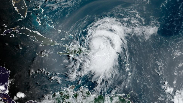
Tropical Storm Ernesto It was circling the Caribbean early Wednesday, just days after Debbie Hurricane Ernesto has completed its journey along the U.S. East Coast. It is expected to become a hurricane sometime Wednesday morning when it passes north of Puerto Rico, where it could bring “heavy rainfall,” according to warnings from the National Hurricane Center.
As of 8 a.m. ET, Ernesto is still a tropical storm, though just barely. The National Hurricane Center said the storm’s sustained winds are around 70 mph with higher gusts. Hurricane status, as measured by Saffir-Simpson wind scaleA state of emergency is declared when wind speeds are between 74 and 95 mph. This does not take into account the size, speed, rainfall, or storm surge, all of which pose additional risks.
Ernesto is expected to become a hurricane later Wednesday, and “could become a major hurricane within a couple of days,” forecasters said. A major hurricane is a Category 3 hurricane, or winds of 111 mph or higher.
President Biden has agreed to Declare a state of emergency The White House said Tuesday evening that it would authorize the Federal Emergency Management Agency to assist with storm recovery in Puerto Rico.
“According to the forecast track, the center of Ernesto will move northward away from Puerto Rico through today. Ernesto is then forecast to move over the western Atlantic Ocean later in the week and approach Bermuda on Saturday,” the Miami-based hurricane center said.
A tropical storm warning has been issued for the United States, the British Virgin Islands, Puerto Rico, Vieques and Culebra. The previous hurricane warning for the British Virgin Islands has been discontinued, and forecasters say Bermuda should monitor the storm’s progress.
National Hurricane Center
Even though Ernesto is dozens of miles away from Puerto Rico, its tail end “is still pummeling the island with heavy rain,” CBS News senior weather and climate producer David Parkinson said Wednesday.
The hurricane center said the storm was expected to produce 4 to 6 inches of rain over the United States and British Virgin Islands and up to 10 inches across southeastern Puerto Rico. Parkinson noted Wednesday morning that more than a half-foot of rain had already fallen in Culebra and Vieques, “with another inch or two to go.”
That amount of rain is causing rivers to overflow. Parkinson said Puerto Rico’s Rio Grande de Loíza “could burst its banks” in the next few hours, while elsewhere on the island “the Rio Blanco rose 6 to 16 feet this morning in less than 90 minutes.”
“The good news is that the river level has fallen as quickly as it rose, down to 10 feet. That’s likely to be the case across the island. The rivers won’t stay above flood stage for long, but they will cause major short-term flooding,” Parkinson said.
While the mainland U.S. is largely out of the danger zone for Ernesto, Parkinson said it could bring storm currents and larger waves to the coast. The Northeast could see waves as high as 8 feet through the weekend, he said, and the Carolinas — still recovering from Tropical Storm Debbie — could see increased waves starting tomorrow.
Ernesto is the fifth named storm so far this Atlantic hurricane season, which has already proven to be Historically, after Beryl reached record strength, Early in the season, temperatures were above average in the Gulf of Mexico. The National Oceanic and Atmospheric Administration predicted an above-normal season, with 17 to 25 named storms, eight to 13 hurricanes, and four to seven major hurricanes.
A fifth named storm usually does not form until August 22According to the National Oceanic and Atmospheric Administration.

“Lifelong food lover. Avid beeraholic. Zombie fanatic. Passionate travel practitioner.”

