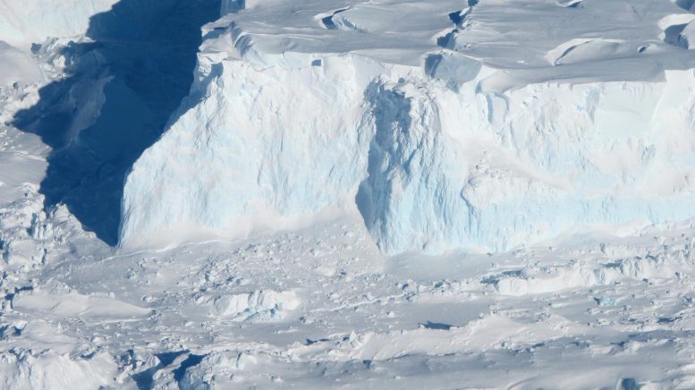
A team led by glaciologists at the University of California, Irvine used satellite radar data to reconstruct the effect of warm ocean water flowing into a grounding zone extending several kilometers beneath the Thwaites Glacier in West Antarctica. Research, topic of research published in With peopleIt will help climate modellers make more accurate predictions of sea level rise resulting from the melting of glaciers that end up in oceans around the world. Image credit: NASA/James Youngle
Satellite radar data shows significant seawater intrusion beneath Antarctica Thwaites GlacierThis causes the ice to rise and fall.
Using high-resolution satellite radar data, a team of glaciologists led by researchers at the University of California, Irvine, has uncovered evidence of warm, high-pressure seawater seeping several kilometers beneath the ground ice of the Thwaites Glacier in West Antarctica. This glacier is often referred to as the “Doomsday Glacier” due to its crucial role in the potential rise of global sea levels and the catastrophic effects such a rise would have around the world. This moniker reflects the glacier’s massive size and melting rate, which scientists believe could contribute significantly to sea level rise if it collapses or melts completely.
The UC Irvine-led team said the widespread contact between ocean water and the glacier – a process repeated throughout Antarctica and in Greenland – is causing “strong melting” and may require a reassessment of global sea level rise projections. Their study was published May 20 in Proceedings of the National Academy of Sciences,
Data and notes
Glaciologists relied on data collected from March to June of 2023 by the Finnish commercial satellite mission ICEYE. The ICEYE satellites form a “constellation” in polar orbit around the planet, using InSAR – interferometer synthetic aperture radar – to constantly monitor changes on the Earth’s surface. Several spacecraft passes over a small, defined area provide smooth data results. In the case of this study, it showed the rise, fall and curvature of the Thwaites Glacier.
“These ICEYE data provide a long series of daily observations that closely correspond to tidal cycles,” said lead author Eric Renault, professor of Earth system sciences at the University of California, Irvine. “In the past, we had some intermittent data available, and with only those few observations it was difficult to know what was happening. When we have a continuous time series and we compare that to the tidal cycle, we see seawater coming in at high tide and receding, and sometimes trending toward Upward under the glacier and getting trapped, thanks to ICEYE, we’re starting to see this tidal dynamic for the first time.
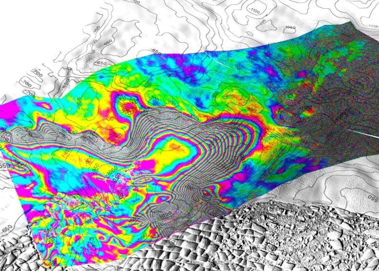
Screenshot of a 3D view of the tidal movement of Thwaites Glacier, West Antarctica, recorded by the ICEYE Synthetic Aperture Radar (SAR) constellation based on images acquired on 11, 12 and 13 May 2023. Contour planes are the topography lines of the layer at altitude 50 meters interval. Each interferential fringe color cycle is a 360° phase shift, equivalent to a 1.65 cm shift in line-of-sight distance to the ice surface. The interferogram is overlaid on a Landsat 9 image acquired in February 2023. In this study, we show that the tidal flexure limit varies by kilometers during the tidal cycle, suggesting that pressurized seawater is able to intrude kilometers below land ice and stabilize Strong heat exchange with the base of the glacier. On the right side of the screen, a discrete bull’s-eye pattern indicates seawater seeping in another 6 kilometers behind a protective ridge, indicating that ice retreat is still continuing, at a rate of a kilometer per year in this critical sector of Antarctica. Credit: Eric Regnot/UC Irvine
Advanced satellite observations
“Until now, it has been impossible to observe some of nature’s most dynamic processes in sufficient detail or repeatability to allow us to understand and model them,” said ICEYE Director of Analytics Michael Wollersheim, a co-author. Observing these processes from space and using radar satellite images, which Providing accurate measurements at the centimeter level at a daily frequency represents a major leap forward.
Renaud said the project helped him and his colleagues develop a better understanding of the behavior of seawater on the lower flanks of the Thwaites Glacier. Seawater coming from the base of the ice sheet, as well as freshwater from geothermal flow and friction, is accumulating and “has to flow somewhere,” he said. The water is distributed through natural channels or collects in cavities, creating enough pressure to lift the ice sheet.
“There are places where the water is almost at the pressure of the overlying ice, so more pressure is needed to push the ice up,” Reno said. “The water is then squeezed out enough to lift a column more than a half-mile long of ice.”
And it’s not just seawater. For decades, Reno and his colleagues have been collecting evidence of the impact of climate change on ocean currents, which push warmer seawater onto the shores of Antarctica and other areas of polar ice. Deep circumpolar waters are salty and have a lower freezing point. While fresh water freezes at zero degrees CelsiusSalt water freezes at a temperature of minus 2 degrees Celsius, and this small difference is enough to contribute to the “strong melting” of the basal ice as found in the study.
Impact on sea level rise and future research
Co-author Christine Dow, a professor in the University’s School of Environment University of Waterloo “Thwaites is the most unstable place in Antarctica and has the equivalent of 60 centimeters of sea level rise,” he said in Ontario, Canada. What is worrying is that we are underestimating the speed at which the glacier is changing, which will be devastating for coastal communities around the world.
Reno said he hopes and expects the results of this project will stimulate more research into the conditions beneath Antarctic glaciers, exhibits involving autonomous robots, and more satellite observations.
“There is great enthusiasm from the scientific community to go to these remote polar regions to collect data and build our understanding of what is happening, but funding is still lagging,” he said. “We are operating on the same budget for 2024 in real dollars that we were in the 1990s. We need to grow the community of glaciologists and physical oceanographers to address these monitoring issues sooner rather than later, but for now we are still climbing Mount Everest in tennis shoes.”
Conclusion and implications for modeling
In the near term, Regnot, who is also a senior project scientist at NASAjet propulsion laboratory (Jet Propulsion Laboratory), said this study will provide lasting benefit to the ice sheet modeling community.
“If we put this kind of interaction between oceans and ice into ice sheet models, I expect we will be able to do a much better job at reproducing what has happened in the past quarter century, which will lead to a higher level of confidence in our future,” the forecast said. “If we can add this process that we explain in the paper, which is not included in most existing models, then the model reconstructions should fit the observations much better.” “It will be a huge win if we can achieve that.”
“Right now, we don’t have enough information to say one way or another how much time remains before ocean water seepage becomes irreversible,” Dow added. “By improving the models and focusing our research on these important glaciers, we will try to determine at least those numbers.” For decades versus centuries, this work will help people adapt to changing ocean levels, while focusing on reducing carbon emissions to prevent the worst-case scenario.
Reference: “Large-scale seawater intrusions beneath the ground ice of Thwaites Glacier, West Antarctica” by Eric Renault, Enrico Ceracci, Bernd Schuchel, Valentin Tolbecken, Michael Wollersheim, and Christine Dow, 20 May 2024, Proceedings of the National Academy of Sciences.
doi: 10.1073/pnas.2404766121
Joining Rignot, Dow, and Wollershiem on this project are Enrico Ceracci, a UC Irvine associate specialist in Earth system science and a postdoctoral fellow at NASA; Bernd Schuchel, a UC Irvine researcher in Earth system sciences; and Valentin Tolbikhin from ICEYE. ICEYE is headquartered in Finland and operates from five international locations, including the United States. The research received financial support from NASA and the National Science Foundation.

“Beer aficionado. Gamer. Alcohol fanatic. Evil food trailblazer. Avid bacon maven.”